CINCINNATI - west
Feb. 1 2022
I've got this feeling that today's the day - to inspect the new Lick Run Greenway! What's the Lick Run Greenway, dare you ask? To find out, peep on!
In 1893, Lick Run had been piped undergound through a 20-foot-wide tunnel - thought to be the biggest public works project ever in the U.S. at the time. Buildings and a park were built over it. I have photos from 2016 of the old park here. Later - and not without controversy - the sewer district launched a project to unearth this creek to control sewer overflow, thus forming this new green space. Most sources say it cost $103 million, but others say over $2 billion. Construction began in 2017, and the greenway officially opened in 2021. The Cincinnati Enquirer called it "the first daylighted stream in the nation to prevent sewer overflows" and said it would reduce overflow by 6 billion gallons per year. An Enquirer photo showed Mayor John Cranley speaking at the 2021 opening, pursing his lips and grasping the podium.
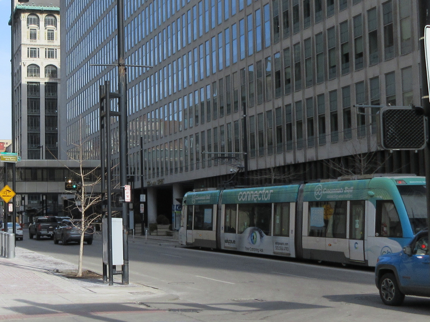
We start this set downtown. This is looking north on Main at 5th. Here you see the oft-ridiculed streetcar. One of few times I've ever seen anyone actually riding the streetcar was during Oktoberfest in 2021, when it was packed with smiling revelers guzzling beer.

East on Government Square at Walnut. Government Square is just a small roadway for buses paralleling 5th. At right along the roadway is the bus platform. At left is the federal courthouse.

West on George between Elm and Plum.

If we don't have this already, we do now! From the bridge where 9th becomes 8th, this is looking northwest through the fence onto Gest Street. The bridge you see over Gest is Linn Street.

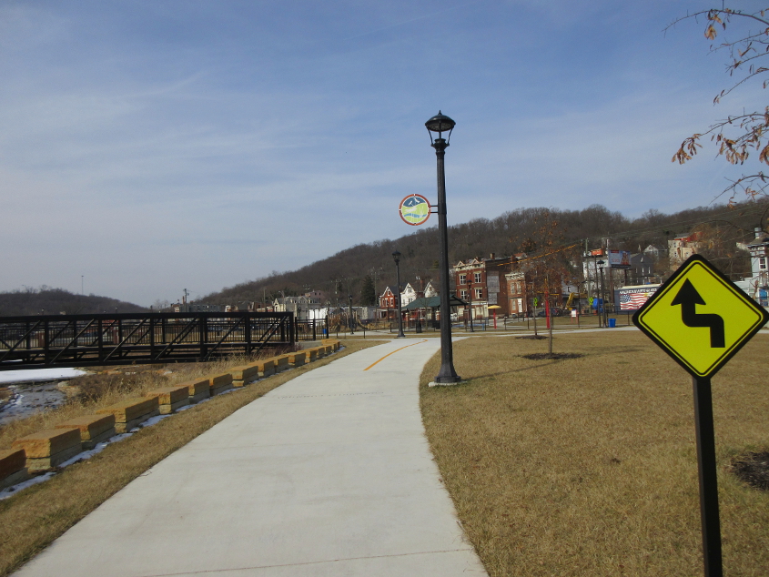
A greenway is a people's road, if you will. Or if you won't. Or if you will but only if poo. The path here is Lick Run Greenway. The icy creek is Lick Run. Notice it flowing into some tunnels at center. In the background at right is the Western Hills Viaduct. This photo was taken from Harrison Avenue where it goes over the greenway and creek.

I think this is looking up Lick Run Greenway, going under Harrison Avenue. The unburying of the creek keeps most sewage separate from stormwater, which saves much water from having to be treated. Unfortunately, the project did cause some old buildings to be torn down. That being the era of gentrification, not tearing down buildings would have been news. Some residents had homesteaded in abandoned buildings and refused to leave even while the structures were being torn down. Some of the limestone from these buildings became stones to line the bank of the creek. It was reported that 91 buildings were affected. The creek reportedly has a separate tunnel underneath it to send some water directly to the treatment plant, but a 2017 document suggests this is the same tunnel the creek used when it was buried.
This is the greenway again, which seems to make a sharp left and go over the creek. It's the geenway, and everything looks geen! As they said in the sandwich bag commercial: Ello and boo make geen, Mommy!

Probably looking back on the greenway. The bridge on the left of the previous photo would be at center here.

Visible here is a new bridge on Grand Avenue where it goes over the creek.

Grand at Westwood.

South on Van Hart over Lick Run. I have a 2016 photo from this spot that shows this street still had buildings. Up ahead, Van Hart meets Westwood. The staircase ahead was closed. Of course.

Looking up Lick Run from Van Hart to the Quebec Road bridge.

Looking down Lick Run from Van Hart to the Kebler Avenue bridge.

West on Queen City at Clifford.

Queen City approaching Ekardt.

They call this the headwaters of Lick Run, indeed they do. Straight ahead, water is flowing out of a slot in the wall and forming the creek.

This has to be going back down the greenway. Thus, Queen City Avenue would be at left and the Harrison Avenue bridge would be straight ahead.

This has to be going under Harrison Avenue.

From State Avenue, looking at the pond formed by Lick Run just before it flows into the tunnels before Mill Creek.

A moment of signy oldness! This is south on Beekman approaching Queen City, where it becomes State.

Surprising I didn't seem to have this yet. This is looking up Tremont from Beekman.

A bad case of sine rot heading onto the Hopple Street Viaduct. I'm guessing this sign was posted in the days when MTV still showed music videos.

Spring Grove at Meeker. This is bannered as "TRUCKS" US 27/127 on the aged sign assembly.

Back north on Meeker at Hopple. Truck US 27/127 is directed left onto the Hopple Street Viaduct with more signs caked with sine rot. Despite that traffic being directed left, another sign says, "RIGHT TURN ONLY."