Kentucky Highway Page
(Updated 3/2023)
|
By not being Delaware, Kentucky is one of the most challenging places in America to do a highway route log. Kentucky leads the U.S. in number of primary highways. While 4-digit primary highway numbers are rare in the rest of America, the Bluegrass State has routes in the 3000s - and this doesn't count the usually "secret" numbers in the 6000s for frontage roads and the like.
Contrast Kentucky with Indiana, which has roughly the same land area and many more people. In Indiana you'd have a tough time finding many state routes even in the 600s.
I got the idea as a teenager in 1987 to create a complete list of Kentucky state routes, and in 1996, I began posting a list on my webpage - one of the first route logs to appear online. I couldn't complete it until 2018, because I was forced to spend many of the ensuing years fighting off spoiled whiners who couldn't resolve their own inner turmoil. Besides, I work for a living, and I have chronic health problems. Oh, there was an urban legend included on this log in its early years, because I'd already grown quite tired of harassment by the aforementioned idiots and I wanted to make them cry, but that's gone now. Case closed.
Most Roads Scholars in America know the simple rules for numbering U.S. and Interstate routes. Kentucky state highways are more haphazard.
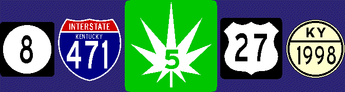
The first numbered route system was created in Wisconsin in 1917, and Kentucky began such a system in the 1920s. KY 1 to 100 were originally numbered so odd numbers ran north to south and increased to the west, and even numbers ran east to west and increased to the south, but this doesn't seem to hold true for newer routes. KY 101 and up seem to be designated sequentially, with countless occurrences of consecutive numbers clustered in a single area. Generally, route numbers are not duplicated on separate highways. For example, there is no KY 27, because US 27 crosses Kentucky. Rare exceptions include KY 79 picking up near where US 79 leaves off. Another is the "secret" KY 471 composed of what is signed as the southernmost stretch of I-471. Duplicate numbers are also allowed on newer Interstate stretches like I-69.
U.S. routes, which were established in 1926, are owned by the states. Interstates were created in 1956 by federal legislation, although the states own and patrol them and pay for their upkeep.
This site is not a primary source for anything except my own comments below each route's main data points. Much of the information here comes from official data you can find on the Kentucky Transportation Cabinet's website...
In 2018, I began automating the main data on this blog by using a FreeBASIC program I wrote to read the shapefile. This is official data, but some typos and other quirks are inevitable. My program also estimates the city, town, or place where each route begins and ends - using an official shapefile of place names. I repeat, this is an estimate.
This log lists many routes that are "secret": No sign marks them as a state route. But all state routes from KY 1 to the 3000s are considered primary routes, even the ones classed as "supplemental" on the official logs, for existing route signs and most maps use the same shield for all of them.
For each existing route, I list: where the route begins and ends, the route's mileage by county, and the route's road names. Mileages and other data exclude parts of the route that "use" another route considered more important. For example, KY 80 loses much of its mileage on this log, because it's overlapped by US 68 for much of its length. The part of KY 80 that piggybacks on US 68 officially carries no mileage as KY 80.
Also, some of my descriptions include political commentary. Some have scoffed at this, but let's face it, the other side has most of the major media to spout their ideas, so they have to be countered. Fair is fair.
This log is best viewed with Chrome. A few older browsers may not format it correctly (like the problem old versions of Netscape have with displaying the shields properly). That's just tough (badeedle-badeed...like your hamburger at - yeah, you know the jingle). All information presented here as fact is believed to be correct based on my personal knowledge and other sources.
|


 This symbol is for descriptions of routes that have been abolished since about 1980. You'll see the county name after this symbol and often the year the route disappeared from the county. (Most of the roads used by these dead routes still exist, however.)